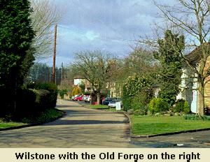
Leave Wilstone down Rose Barn Lane or Rose Lane as was known taking the footpath to Dixon’s Gap, the footpath starts at the end of Rose Barn Lane passing the new allotments and opens out on to what are ancient fields and tracks. You can still see the remnants of double hedge rows. Follow the path around the periphery of the field to a small gap once a style which takes you across centre of a large arable field to some crude steps down to the towpath. The new Dixons Wharf estate can be seen to the left through the trees. Turn right and continue along the tow path towards Marsworth The Alyesbury Arm of the Grand Union Canal is popular spot for fishing and contains a wide variety of species including large Common and Mirror Carp up to around 20lbs. If you are quiet you may catch site of one swimming just below the surface. They also occasionally leap out of the water with large splash! The Dixon’s Gap pound is well protected from the elements by high hedges on both sides providing cover for many birds, you maybe lucky and catch site of kingfisher, a flash of iridescent blue in the sun light. Also listen out for the laughing call of the green woodpecker. Moving on, as you pass under the road bridge and up on the next pound you may disturb a Heron fishing also look out for them on the adjacent fields. This is a very open stretch of the canal as you wander along listen the calls of the Lapwing a high pitched “pee wit”. During the summer and autumn there are often large flocks on the fields to your right which are often disturbed by Hot Air Balloons when they all take to the air calling loudly.
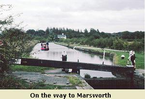
As you move onto the next pound with its very attractive lock keepers house you may hear the “mew mew” call of the Kestrel from the trees and hedge rows to your left also Magpies can be seen, often feeding on the tow path. The tree lined next pound is very attractive, as you approach the far lock if the water is calm you may see some torpedo shaped fish up to a foot long just below the surface these are Chub more usually at home in shallow fast flowing rivers. Moving up to final pound you can take seat for a while and look out over fields towards Marsworth. As you climb up the steps to join the main arm of the Grand Union you pass a double lock for boaters to negotiate and join the main arm. At this point the canal is very wide and provides permanent moorings for many long boats. As you approach the road bridge there is special sight to see, take a good look in the water and you may see a large shoal of big carp. Many people feed them and if you were very patient I am sure they would eat from your hand.
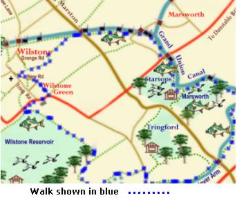
Pressing on, you now have to cross the main Road. You can take some refreshments at the Bluebell Cafe or just down the road is the Anglers Retreat. Follow the tow path until it splits, take the right fork up to the corner bank of the Startops End Reservoir (built in 1815-17 and then bear left keeping the canal to left and Marsworth Reservoir (built in 1806) to your right. These reservoirs were built to supply the canal with water. Early in the year the year the water levels are high but each time a boat moves through one of main arm locks it takes 56,000 gallons (250,000 litres) of water to refill it! So in the late summer the water levels particularly Startops drop dramatically. The reservoir is home for many water birds - grebe ducks geese and swans, it also contains very large fish, carp and pike and catfish. This is very attractive part of the walk along the bank of the reservoir and looking down on the busy canal on the other side. Reeds beds line reservoir and eventually opens out with a view of a large reed bed. Boats moving through locks seem to have a special fascination and many people stop to watch the activities. The pounds are short and wide as you approach the summit of the Grand Union at around 390 feet above sea level.
 You
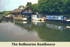
reach the summit and a footbridge with a boathouse to your left, cross the bridge and
turn sharp right to take the path leading back under the bridge. You are
now on the Wendover Arm, this is very quiet stretch with few boats. The
arm was built 1793 and follows the 390 foot contour line all the way to Wendover suppling water from the Wendover Hills to the Tring summit. You will pass on your right the site of one of early pumping station that
lifted water from Marsworth reservoir to the summit. This pump house only ran from 1810 to 1817 when it was replaced by Tringford Pumping station which you come across shortly. The path winds
around to Gamnel Bridge at New Mill where again you have to cross a busy
road to rejoin the towpath on the right of the canal. Heygates flour mill
is on your left, the site of a what was once a busy boat yard. Further on you
will see on the left the small Tring feeder joining the canal. Apart from
this feeder all other water has to be pumped up into the canal. The canal
now narrows and is very shallow as it flows through open fields towards
Little Tring. But first you reach Tringford Pumping Station which pumps
water from all four reservoirs into the arm to feed the summit of the main canal. The original
Pump of 1818 was a steam driven beam pump and was replaced by a diesel electric pump in 1913. For the next few
miles the canal is dry but work is in progress to reopen it. The other side of the road bridge the canal opens into a basin and you may see several boats moored here,
Leave the canal to your right and join the road at Little Tring. Walk up the hill for 100 yards or so and you will see
track to your left which leads to the tow path of the “Dry Canal”. This
part of the canal through to Drayton Beauchamp leaked and was closed
in 1904. The water is diverted into an 18 inch pipe laid in the bed of the canal.
You
reach the summit and a footbridge with a boathouse to your left, cross the bridge and
turn sharp right to take the path leading back under the bridge. You are
now on the Wendover Arm, this is very quiet stretch with few boats. The
arm was built 1793 and follows the 390 foot contour line all the way to Wendover suppling water from the Wendover Hills to the Tring summit. You will pass on your right the site of one of early pumping station that
lifted water from Marsworth reservoir to the summit. This pump house only ran from 1810 to 1817 when it was replaced by Tringford Pumping station which you come across shortly. The path winds
around to Gamnel Bridge at New Mill where again you have to cross a busy
road to rejoin the towpath on the right of the canal. Heygates flour mill
is on your left, the site of a what was once a busy boat yard. Further on you
will see on the left the small Tring feeder joining the canal. Apart from
this feeder all other water has to be pumped up into the canal. The canal
now narrows and is very shallow as it flows through open fields towards
Little Tring. But first you reach Tringford Pumping Station which pumps
water from all four reservoirs into the arm to feed the summit of the main canal. The original
Pump of 1818 was a steam driven beam pump and was replaced by a diesel electric pump in 1913. For the next few
miles the canal is dry but work is in progress to reopen it. The other side of the road bridge the canal opens into a basin and you may see several boats moored here,
Leave the canal to your right and join the road at Little Tring. Walk up the hill for 100 yards or so and you will see
track to your left which leads to the tow path of the “Dry Canal”. This
part of the canal through to Drayton Beauchamp leaked and was closed
in 1904. The water is diverted into an 18 inch pipe laid in the bed of the canal.
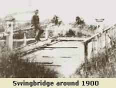
You are now high above Wilstone Green and Village to the right and ahead is Wilstone Reservoir. The path comes to junction originally the site of a swing bridge across the canal but now replaced with a wooden foot bridge, turn right and drop down towards the reservoir at bottom of the slope turn right and follow the track turning left on to the East Bank of the reservoir. As you look out over this large expanse of water you will see that reservoir appears to be divided into three section and in fact the the reservoir was built as 3 separate reservoirs between 1802 and 1839. The original reservoir, now the SW corner had its own pumping station (1802-36) at the 'WhiteHouse' high above reservoir on the Wendover Arm. The ruins can still be seen.
Wilstone Reservoir is a very well known
spot for fishing holding some lage pike tench and perch. Bird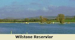 watching is very popular, it attracts from time to time many of the rarer species. In late autumn when the levels are low you can see large flock of lapwing and golden plover with other rarer wading birds, Winter see the arrival of large numbers of ducks, geese and swans again. In the late spring early summer you may catch site of a hobby hawking up and down reed bed for dragon flies which they catch in their talons and transfer to it beaks while in flight.
You are nearly back to Wilstone continue along the bank until you reach the steps down to road level Turn right and take the path until you reach
the turning for Wilstone or carry on past farm shop and at the corner take
the path down through Great Farm and into New Road.
watching is very popular, it attracts from time to time many of the rarer species. In late autumn when the levels are low you can see large flock of lapwing and golden plover with other rarer wading birds, Winter see the arrival of large numbers of ducks, geese and swans again. In the late spring early summer you may catch site of a hobby hawking up and down reed bed for dragon flies which they catch in their talons and transfer to it beaks while in flight.
You are nearly back to Wilstone continue along the bank until you reach the steps down to road level Turn right and take the path until you reach
the turning for Wilstone or carry on past farm shop and at the corner take
the path down through Great Farm and into New Road.